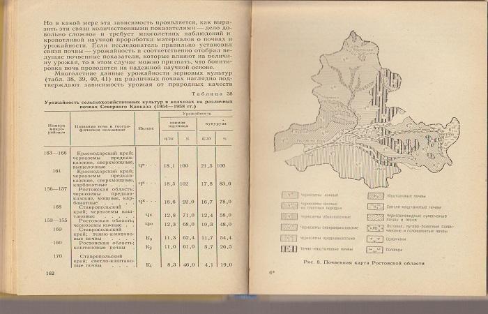
Soil grading is a comparative description of the quality of agricultural land. For this purpose, special soil surveys are carried out and the corresponding points are assigned. The procedure is carried out for land assessment, land reclamation, maintaining the land cadastre and other tasks. Using soil quality, it is possible to predict plant productivity. It is also used to assess the value of land, determine the amount of taxes and rent.
What is soil booting?
This term refers to the definition of fertility. Grading is a comparative assessment of soils in points based on basic agronomic characteristics.The procedure is carried out to economically characterize the land. Bonitet is also needed to resolve issues of pricing, maintaining a land cadastre, and improving farming systems.
Most often, valuation is used for on-farm assessment of land based on production and technological characteristics. The first group includes plant productivity and the productivity of forage lands, the second group includes relief, remoteness, rockiness, and energy intensity. The procedure is also aimed at assessing land based on the costs of growing crops and determining cost effectiveness.
Soil grading is expressed in generalized parameters – points. As a rule, materials from soil surveys are used as a basis. They reflect the mechanical composition of the soil, the humus content in it, acidity parameters, and important physical characteristics.
primary goal
The key goals of grading are the accounting and grouping of soils according to their natural characteristics and fertility. At the same time, an assessment is made of soil productivity for cultivation for different plants, improvement of agricultural production and specialization. Each type of soil is characterized by a certain quality rating, or quality indicators, productivity, and quality factor.
Experts identify the following purposes of valuation:
- comparison and grouping of soils and land according to productivity, that is, fertility;
- identifying the most favorable lands for various crops;
- production assessment of a country, region or specific farm;
- objective assessment taking into account soil and climatic conditions with the result of economic activity and identification of production resources;
- assistance in the rational implementation of agricultural systems;
- assistance in the correct preparation of measures to increase the fertility and yield parameters of cultivated plants in different types of soil.
Boot criteria
The main indicator by which land is assessed is fertility. It can be natural, artificial, economic, potential. Relative and effective fertility are also distinguished.
As a grading criterion, it is important to use those parameters that directly characterize fertility. This term refers to the ability of soils to provide plants with all the necessary nutrients and create favorable conditions for their growth.
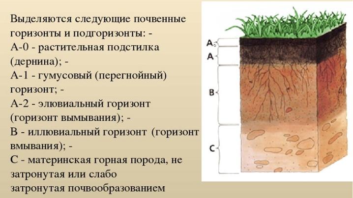
The main parameters that are used to characterize soil fertility include humus reserves and the thickness of the humus horizon. In this case, the soil may have favorable physical properties and contain the required amount of moisture, but if there are negative characteristics, its productivity will decrease. Negative properties include salinity, acidity, and salinity.
The main criteria for soil grading that are used today include the following:
- thickness of the humus horizon;
- humus reserves;
- physical clay content;
- bulk density;
- physical characteristics;
- minimum moisture capacity;
- aeration porosity;
- range of active moisture.
Preparation
At the stage of preparation for valuation, it is necessary to draw up republican and regional valuation scales. In this case, objective parameters and characteristics of the soil are used. Soil scientists are involved in compiling such documents.It is important to use statistical data.
When compiling grading scales based on soil characteristics and parameters of its productivity, the following types of information are used:
- Soil map, materials from large-scale ground surveys of farms, soil reports with analytics, tables of land areas.
- Climatic information, including average long-term temperature, average annual precipitation, duration of the frost-free period.
- Materials on state registration of land users.
- Literary information regarding the assessment of land in the region.
- Annual reports of collective and state farms for 5 years.
- Information on long-term yields in areas with different types of soil.
Techniques
Recently, soil-ecological assessment has been predominantly used. It helps to determine indicators and assign scores for different areas and at any levels. To do this, use the following parameters:
- soil indices - they are calculated taking into account erosion, rubble, and deflation;
- average humus content;
- agrochemical parameters - these include soil acidity indicators, nutrient content ratios;
- climatic indicators – sum of temperatures, humidification coefficients.
Then the final parameters are calculated - climatic, soil, agrochemical. After this, a final assessment is carried out, which includes determining the soil-ecological index.
Soil grading is considered an informative technique that helps assess soil fertility. By determining the main indicators, it is possible to predict plant yields and determine the value of land.

